The more we immerse ourselves in the online maps, the clearer it becomes that all maps are provisional. Two dimensions can never truly embody four. Contour lines and hill-shading might approximate the third dimension, but the fourth, time, is always out of reach. Every map is only a snapshot of a moving train.
What prompted such fortune-cookie musings is growing awareness of the disparities between the place-names listings on the site and the new maps that represent them. The listings are based on the 1851 Townlands Index, which reproduces the standardised place-names used for the 1851 census. These standard versions were created by the Ordnance Survey between 1831 and 1841 and were also used by Griffith for the Primary Valuation. The problem is that some of the Ordnance Survey parish boundaries in the Index had changed by the time Griffith came surveying.
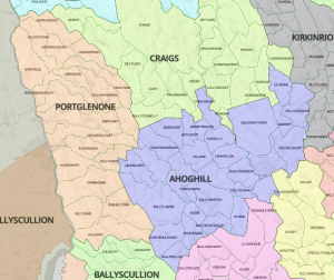
The most egregious example is the parish of Ahoghill in Antrim. In the 1851 Index, this consisted of a huge area, almost 150 sq km, roughly 60 square miles. By the time Griffith’s surveyors arrived in the late 1850s, it had been divided in three, Ahoghill, now down to c. 50 sq km/20 sq m, Craigs (51 sq km) and Portglenone (44 sq km).
 So, do we stick with the 1851 listing and break the connection to the Griffith’s records? Or mess with the 1851 to make it fit Griffith? The aim of the site is to provide tools and shortcuts for research, not to reproduce prefect facsimiles, so there can only be one choice. Messing and Griffith’s it is.
The Antrim map is already rejigged to represent the 1861-62 Griffith’s survey. Now we just have to pick apart all the record listings for Ahoghill and reknit them into the three smaller parishes. Argh.
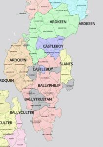
Because Griffith’s was published relatively early (1847-1854) for southern counties, with Ulster counties appearing in the 1860s, the areas most affected by the discrepancies are in Derry, Fermanagh, Antrim and Down. Parishes on the Ards Peninsula in Down appear to have been shuffled crazily in the 1860s, with the mapped areas bearing very peculiar relationships to the listings. There are many, many townlands mapped into one parish, but recorded in another in the Valuation.
We’ll correct the worst offenders over time, but in many cases the effort is pointless. It’s also not clear that some of the parishes scattered in multiple parts on the maps are entirely accurate, at least for Griffith’s. So sup with a longish spoon and gird your loins with that trusty genealogical scepticism.
(A quieter caveat is that we’ve finally implemented the soft paywall for the maps. In the first flush of enthusiasm we forgot about it.
But even without paying, almost everything is free via zooming on the county pages (e.g https://www.johngrenham.com/browse/county_civil.php?county=Roscommon), with the paywall counter starting only if you click through to a parish page. Shh.)
This is brilliant and will be so much help to us as we struggle to find our Irish ancestors. Thank you!
Your Murphy map is very eye opening…
As the Y DNA for my Slevins from Dromore, County Tyrone matches a lot of lost Murphy’s…across the world…with one possibly from the Ballygawley/Aughnacloy,County Tyrone region…just over the Slevin(hills) from Dromore, County Tyrone…
Upon arriving in Highland, VA/WV in the early 1700s our Dromore, Tyrone Slevin/Slavin/Slavens went on to be the founders of one of the most persistent WV and Ohio River Valley hillbilly families…
Could this be a corollary of “…You can take the Irish out of Ireland, but you cannot take Ireland out of the Irish…”…i.e…”…you cannot take the hillbilly out of the Slevin…” …or …”…you can take some of the poteen makers out of the Tyrone…but you should not be surprised that they are still making 5 star white lightening…in them thar hills of Tyrone and West Virginia 300 years later..??..”
Maybe the alcohol manufacture and consumption of the Irish could be the 5th dimension of your research and maps..
Thanks as always for your hard work…!!..
Thanks for the great work, John!