
After putting up the all-singing, all-dancing, click-and-zoom civil parish maps in July, it occurred to us that the townlands available from Open Street Map (townlands.ie) would fit nicely into them. If we just could get the data down to manageable file-sizes. So we squeezed and squeezed and … Whoopee. All-singing, all-dancing, and now break out the top hat and cane.
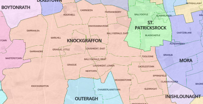 Then, after repeatedly hunting inside various parish maps for a townland, we thought it would be nice if you could just click on the townland name to drop a marker showing exactly where it was. So we did that. Yeehaww. All-singing, all-dancing, add white gloves to the top hat and cane.

But that only worked if the townland names on the maps matched those in our own listing. And in about 10% of cases, more than 6,000 names, they didn’t. As my Auntie Breda used to say, it would give you a pain in your Laladooshia. But there was no choice. At the end of July, we began the process of standardising the names, one by irritating one. There were plenty of typos in the OSM lists and (mumbles) one or two in our own. Many came down to commas and brackets and hyphens. The standard we aimed for was the Griffith’s spelling, so no Irish-language versions are included, and nothing later than the 1860s. This is where the differences between OSM and ourselves came into play: They aim for contemporary geographical accuracy; we just want to make it easier and more intuitive to get at the records.
Anyway, that process ended last week, with about 98% of place names now plonking down markers when you click them.
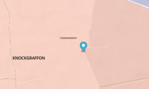
Then the fact that the markers were unclickable began to annoy me. Don’t just sit there, you lazy little marker, do something. So I made a popup from the marker to include links to records covering that townland: Griffith’s, civil BMD records, 1901, 1911. 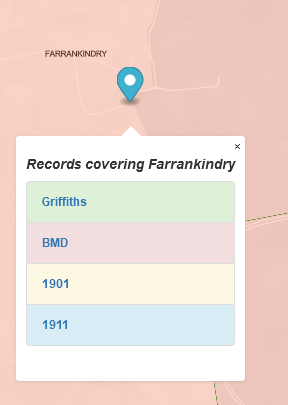 Wahey, the circus is in town.
 What this means is that for 98% of townlands in rural Ireland, you can now click through to the universally relevant records from the 1850s to the 1920s, while seeing the location of each townland in relation to its neighbours. A historical snooper’s dream: in other words, mine. Enjoy.
(In the course to the eyeball-to-eyeball engagement with the townlands, I came across some doozies. Here, for your delectation, are a few of my favourites:
-
-
- America and Liberty, just across the fields from my ancestral homeplace, probably testament to local eighteenth-century support for the American Revolution.
- The geographically confused: Gibralter, Antigua, Siberia, Lilliput and the hard-to-find Castlelost.
- Rows that got out of hand: Bastardstown, Slutsend, Stranglewilly, Controversyland
- Good, plain Presbyterians: John Gillins, True, Christendom)
-