
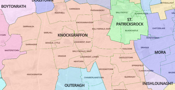
After putting up the all-singing, all-dancing, click-and-zoom civil parish maps in July, it occurred to us that the townlands available from Open Street Map (townlands.ie) would fit nicely into them. If we just could get the data down to manageable file-sizes. So we squeezed and squeezed and … Whoopee. All-singing, all-dancing, and now break out the top hat and cane.
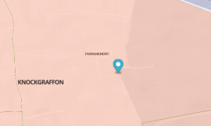
 Then, after repeatedly hunting inside various parish maps for a townland, we thought it would be nice if you could just click on the townland name to drop a marker showing exactly where it was. So we did that. Yeehaww. All-singing, all-dancing, add white gloves to the top hat and cane.
But that only worked if the townland names on the maps matched those in our own listing. And in about 10% of cases, more than 6,000 names, they didn’t. As my Auntie Breda used to say, it would give you a pain in your Laladooshia. But there was no choice. At the end of July, we began the process of standardising the names, one by irritating one. There were plenty of typos in the OSM lists and (mumbles) one or two in our own. Many came down to commas and brackets and hyphens. The standard we aimed for was the Griffith’s spelling, so no Irish-language versions are included, and nothing later than the 1860s. This is where the differences between OSM and ourselves came into play: They aim for contemporary geographical accuracy; we just want to make it easier and more intuitive to get at the records.
Anyway, that process ended last week, with about 98% of place names now plonking down markers when you click them.
Then the fact that the markers were unclickable began to annoy me. Don’t just sit there, you lazy little marker, do something. So I made a popup from the marker to include links to records covering that townland: Griffith’s, civil BMD records, 1901, 1911. 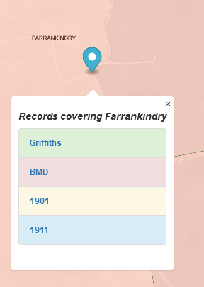 Wahey, the circus is in town.
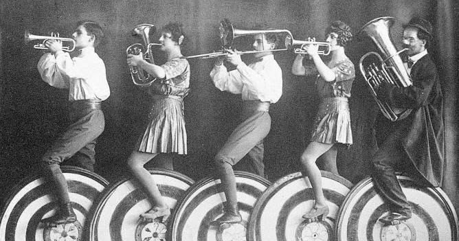
 What this means is that for 98% of townlands in rural Ireland, you can now click through to the universally relevant records from the 1850s to the 1920s, while seeing the location of each townland in relation to its neighbours. A historical snooper’s dream: in other words, mine. Enjoy.
(In the course to the eyeball-to-eyeball engagement with the townlands, I came across some doozies. Here, for your delectation, are a few of my favourites:
-
-
- America and Liberty, just across the fields from my ancestral homeplace, probably testament to local eighteenth-century support for the American Revolution.
- The geographically confused: Gibralter, Antigua, Siberia, Lilliput and the hard-to-find Castlelost.
- Rows that got out of hand: Bastardstown, Slutsend, Stranglewilly, Controversyland
- Good, plain Presbyterians: John Gillins, True, Christendom)
-
OMG man! You are brilliant, insane and I (and I’m certain everyone who has ever struggled with a Griffith’s map) am extremely and beyond grateful! ????
Right on!
Thanks. Can’t wait to get at it!
John, another excellent painstaking piece of work, which is just absobloominlutely wonderful for amateur or professional genealogists.
Kudos for the countless hours of hard work.
Thanks ever so much for this.
Sheila Marney
14:33 British Summer Time.
John, I know that Heavenly Father has been helping you all along in this important work. Thank-you and G_d bless you in this sacred work I pray in the name of Jesus Christ, Amen
What a dedicated and inspirational man you are for us poor unfortunates!!!
Many thanks for your continued and invaluable work that you do for all the
many novice and equally dedicated family genealogy researchers.
Very best wishes for your continued work.
What can I possibly say other than you are an absolute treasure! Many, many thanks.
Love your blog posts and YouTube videos.
My ancestors lived in(near) an Irish “four corners”(four states meet, Arizona, New Mexico, Colorado and Utah at a single point.)
Three townlands(Lyravarrig Commons and Tooreen), three registrar districts(Carrignvar #2, Ballyhooly and Rahan) and three superintendent districts(Cork, Fermoy and Mallow) meet at a single point just north of Cork City.
Lyravarrig is a townland in Ardnageehy(Watergrasshill) parish which is in Carrignavar #2 Registrar within Cork Superintendent District. Immediately adjacent was the townland of Knopogge(in Ardnageehy) in Ballyhooly Registrar District of Ballyhooly reporting to Fermoy Superintendent District. Tooreen townland touches Commons (a townland in Ardnageehy which is situated right in between Lyravarrig and Knopogge). Tooreen is in Monanimy(Killavukllen) parish part of Rahan Registrar District situated within the Mallow Superintendent District. Immediately north of Tooreen is Beennaskehy townland which is in Monanimy Rahan and Mallow too respectively.
Denis Buckley(1859-1944) of Lyravarrig wed Margaret Callaghan(1859-1951) of Knoppoge at her father’s house and raised a family at Lyravarrig. His first cousin Nora Buckley(1865-1953) was born at Beennaskehy. She moved to Cork City and raised her family on St. Finbarr Street. His youngest son(1903-1984) wed Nora’s youngest daughter(1901-1988) in NYC. My grandparents were second cousins and this updated maps is awesome to show where all the townlands were in a single picture across parish, registrar district and superintendent district boundaries.
Absolutely amazing! Thanks for making the difficult more easy.
Thank you, thank you, thank you! The collective genealogist man hours you’ve saved are immeasurable.
Now if your elves could work on overlaying civil and parish maps, we’d be forever in your debt. FamilySearch did if for England so why not Ireland? It’s good to have a dream, eh?
Thank you for all of this work–so nice to have someone like you ask the questions that no one else could think of much less answer. The “doozies” made me laugh outloug@
Excellent! This will save so much work! Next step: overlaying the Catholic parishes over the civil parishes. I have done that for several counties using a light box and sharp pencil, but so difficult to be precise.
Remarkable, incredible, SO helpful!! You are amazing! Thank you Thank you Thank you!!!
Thank you so much!!!
You rock, John!!!
Janet Cassidy
John,
I just last week found you, and I will never let you go!
Thank you!!
Informative, brilliant and fun all at once. Are you married John? Seriously, thanks for all you do.
This is truly amazing and a huge help. Thank you, thank you!
How fantastic John and thank you. I use your site all the time for the many insights it brings.
You must be getting fit from all that singing and dancing.
Thank you, John. YOU ARE BRILLIANT! I also love your wit.
Very cool!
You, Sir, are amazing and soooooooooo appreciated!!
This is a wonderful tool! Thank you!
Honeymount townland on the national archives tithe apploment site is listed in Dunkerrin Parish, County King’s (now Offaly) but here it is in Rathnaveoge Parish of County Tipperary.
What is really interesting when you look at the maps of the 2 Parishes they fit together like 2 puzzle pieces are supposed to.
So I think either the boundary changed or one of these sites is wrong. Any help would be appreciated.
Lordy! Lordy! Lordy! John Grenham if you were closer I’d give you an enormous smooch! Just not quite like the Spanish FIFA bloke!!
Heavenly job! Possible sainthood awaits! Or not, if you’re not that way inclined!!
Thanks
Chris Owen nee McCormack from Oz via Counties Tyrone Galway Clare and Waterford. All 98% of me!
I can only imagine the hours and hours this must have taken. All I can say is thank you, John. I appreciate this latest stroke of genius that you are sharing and need all the help I can get!
Well done !
Thanks very much for this excellent resource , John. It will be widely used over the next few months.
Still unsure of the ancestral town lands but your hard work in making it easier for your audience is much appreciated John
Thank you so much for all of your hard work! I’ll be so grateful when I get the chance to get back to my ancestry search!
Absolutely fantastic! Thank you!
Oh I hope this doesn’t sound like a left-handed compliment – but this is perhaps the most useful thing you’ve accomplished yet. Brilliant. I will print front this endlessly and plot out all the families in Mayo. There’s nothing else out there like it; thank you!
Great work John and all involved. It’s always great having this information in one place. Are there any plans to link in the schools folklore collection for some of the civil parishes?
Is there a link to using this wonderful townlands resource, or where do I find it, please? It sounds wonderful! Thank you.
https://www.johngrenham.com/places/civil_index.php
Wow!! What a colossal achievement… with dancing, top hats, and all!! I’m impressed, and grateful for all your work here. The #1 site for Irish genealogy research IMHO! Thank you.
John, you have slain the jabberwocky! Kudos to you, with sincere gratitude for all your amazing hard work. And I absolutely love the brass band.