| Accompanying Lewis map for Galway 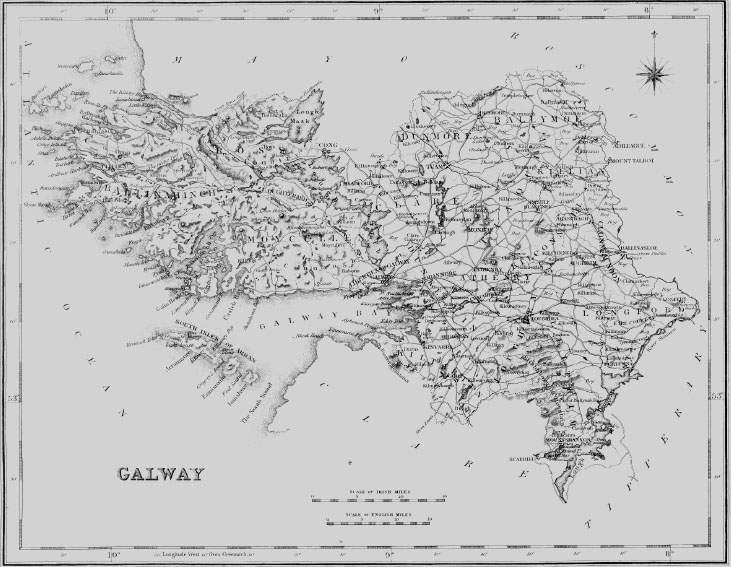
|
| BALLYNAKILL |
| BALLYNAKILL, a parish, in the barony of HALF-BALLYMOE, county of GALWAY, and province of CONNAUGHT, 6- miles (W.) from Roscommon; containing 4315 inhabitants. This parish is situated near the road from Roscommon to Dunmore, and comprises about 3000 acres of arable land, about 20,000 acres of mountain pasture, and nearly the same quantity of waste, mountain, and bog. It is a vicarage, in the diocese of Elphin, arid forms part of the union of Donamon; the rectory is impropriate in Viscount Ranelagh. The tithes amount to £230. 10., payable in moieties to the impropriator and the vicar. In the R. C. divisions it is the head of a union or district, called Glinsk and Kilcroan, which comprises the parishes of Ballynakill, Clonigormican, Ardclare, Oran, and Kilcroan, and contains two chapels, one of which is situated at Glinsk, in this parish. There are five hedge schools, in which are about 270 boys and 70 girls. |
| CRUMP |
| CRUMP, or ILANE-A-GREEN, an island, in the parish of BALLYNAKILL, barony of BALLYNAHINCH, county of GALWAY, and province of CONNAUGHT, 10 miles (N. E.) from Clifden. This island, which is inhabited by only one family, is situated near the entrance of Ballynakill harbour on the western coast, and contains about 70 statute acres of arable land. |
| WOODFORD |
| WOODFORD, a town, in the parish of BALLYNAKILL, barony of LEITRIM, county of GALWAY, and province of CONNAUGHT, 6 miles (W. S. W.) from Portumna, on the road from Loughrea to Killaloe : the population is returned with the parish. It is situated on the Rossmore river, which flows into Lough Derg on the Shannon, and is here crossed by a bridge, and about two miles below the town by Rossmore bridge, to which latter the river is navigable at present for boats of about 20 tons' burden. It has been proposed by the Government engineers to improve the navigation of the river, to form a good road from Woodford to Rossmore bridge, and at the hatter place to construct a quay and other accommodations for the shipment of agricultural produce. About 60 years since an extensive iron-foundry was carried on here, and, 20 years subsequently, the manufacture of salt ; iron ore is supposed to exist extensively in the neighbouring mountains, and evidence of the old iron-works may still be seen adjoining the town, where there is a stratum of cinders from three to four feet deep. Here is a mill for grinding corn. Fairs are held on March 18th, May 12th, June 25th, and Dec. 26th. There is a good barrack, at present occupied by one company of infantry ; and a constabulary police force is stationed in the town. A seneschal's court for the recovery of small debts is occasionally held. Here are the parochial church, a neat building ; and the R. C. chapel of the district of Woodford. Marble Hill, the seat of Sir John Burke, Bart. ; and Eagle Hill, of Capt. Pigott, are in the vicinity. On Benmore mountain, about ? mile north of the town, is a quarry of fine freestone, capable of furnishing blocks of large dimensions, adapted both for useful and ornamental purposes ; and should the proposed improvements be carried into effect, it is likely to be worked to a considerable extent. Near the town is a chalybeate spa, formerly used with success for medicinal purposes. |
|