Remote and alien pagan babies. And 1916

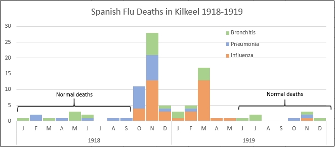
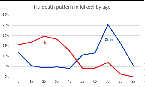
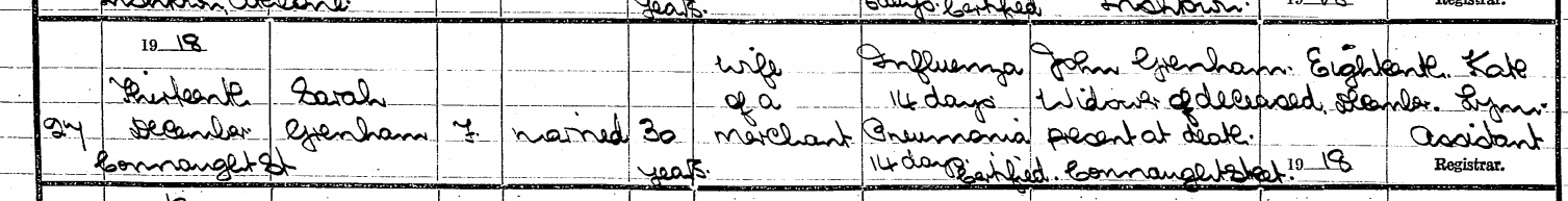
One of the joys of genealogy is coming eyeball to eyeball with the past in all its weird particularity. It produces two apparently contradictory effects. On the one hand, you get to appreciate that a century ago (or twenty centuries ago) human beings everywhere were just as human as we are, with all the fears and desires that we have. On the other, you realise how alien and remote the past can be. It is just not possible to recapture what it felt like to live inside the elaborate warrior-dominated caste system of pre-medieval Ireland or to be forced out of a WW1 trench knowing you face instant, certain death.

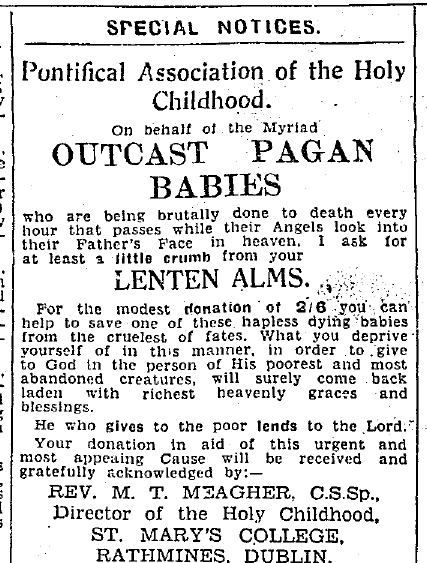
Alien and remote: Irish Independent Apr 1, 1939

So when I saw the tag-line for the GPO 1916 museum in Dublin – “So real you almost smell the gunsmoke” – my hackles rose. What about the smell of gangrene? Or the dead horses rotting out on Sackville Street? The museum (full title “The GPO Witness History Museum & Visitor Centre“) has won international awards, provides a nice day out and does what it does very well indeed. But what it does is provide immersion in a sanitised past, a theme park version of history carefully relieved of anything truly strange or upsetting.

This obligation to immerse seems to be part of a bigger trend in the leisure sector, of which history and genealogy are now minor branches. So 3D cinema is no longer enough, we’re now on to 4D. Which apparently involves splashing water on everyone when a boat appears, puffing out scent to accompany flowers and (one can only hope) eventually disembowelling an audience member live during ‘Halloween 39: Great-Grandson of Freddie’.

Immerse yourself

The Spanish Flu and Irish family history

Over the course of 52 months, the First World War killed around 16 million people. In twelve months, the 1918/1919 influenza pandemic killed at least 50 million, and possibly twice that number. It was the greatest medical holocaust in history, destroying more lives in 24 weeks than AIDS in 24 years, and more in a year than the Black Death killed in a century.

Camp Funston, Kansas, 1918

Why does it not loom larger in our historical awareness? One reason is official suppression of its scale. Although the earliest known outbreaks were among US troops in Kansas and near Étaples on the Western Front, wartime censorship blocked  reports of the pandemic in the countries at war. Because Spain was neutral, the pandemic’s effects could be freely reported. As populations sickened and died, they heard more about the effects in Spain than in their own countries. Hence “Spanish Flu”.

In Ireland, it came in three waves. The first recorded outbreak was on the troop carrier the USS Dixie off Cobh in May. That early wave was relatively mild – those who survived acquired immunity to the two later waves. The most lethal of these came in November 1918, just as the War ended, and a last, less deadly wave arrived in spring 1919.

What does any of this have to do with genealogy? One of the great successes of recent genealogy in Ireland has been to recover, family by family, the suppressed histories of the Irishmen who fought in the First World War. Perhaps something similar needs to be done for those who died in the Spanish Flu.

The tools are already at our fingertips and perfectly adapted. The civil death records on IrishGenealogy provide detailed causes of death, day by day, district by district, and can be minutely examined using the site’s “more search options“.

An example of what can be done by a local historian is Dermot Balson’s brilliant work on Kilkeel in Down. His two charts, based on these death records, show just how brutally the flu impacted on the area between October 1918 and March 1919, and how young adults died disproportionately.

A single page from the death registers of Athlone No. 1 district between December 12 and 19 1918 shows why a genealogist might also be interested. Out of the ten deaths listed, nine are influenza related. And the second last is the death of my grandfather’s first wife at the age of 30. He remarried two years later, to my grandmother.


More maps than you can shake a stick at

Like everyone involved in Irish genealogy and local history, I spend a lot of time looking at Griffith’s Valuation on askaboutireland.ie. Griffith’s is the only Ireland-wide census substitute for the mid nineteenth century and the site is wonderful, not least because it is free.

One feature, though, has caused much grief to users over the years, the mismatch between the printed records and the maps that accompany and supposedly illustrate them. The maps used on the site date from several decades after the publication of the Valuation, and so can differ starkly from the printed original.

More than 20 years after the published Valuation

The reason is that Griffith’s was a live property tax survey. So for a century and a half the Valuation Office had to record changes in occupier, holding size, lessor – anything that could affect the value of a holding and thus the tax to be paid on it. Handwritten, copybook-style versions of the original were used to list the changes, which were then hand-marked on the Office’s own copies of the six-inch Ordnance Survey maps.

The wonderful little slider

The main maps used by askaboutireland consist of one full baseline set of these map revisions, dating from the late 1870s, more than two decades after the publication of the books. It has to be said that the mismatch between printed books and maps is more than made up for by the layering of the maps over contemporary Google maps and satellite images.  Their wonderful little slider makes it possible to move back and forth between the 1870s and today, with detail right down to the level of individual fields and streets. Many users find themselves entranced: “What, 4 a.m. already?”

But these are not the only maps on the site. Every single working revision map from the Valuation Office (Republic of Ireland ony) now appears to be there, layered one over the other, with up to eight separate maps for some areas. And no way of telling which follows which.

How to use them? When the full handwritten revision books eventually become available online, it may be possible to date the maps by comparing them with the written records, though most of the VO maps lack the lot outlines of the main series that would make such connections possible.

Be reassured: it’s not just you. Everyone is floundering.

Ballina on the VO five-foot map

For the moment, by far the most useful of these are the VO town plans. These are part of a series of more than 1400 maps drawn up by the Ordnance Survey specifically for Griffith, at the phenomenal scale of five feet to the mile, ten times more detailed than the OS main series. Though also undated, they do include lot and house numbers, making it possible to follow the fate of every building in every street.  They should be top of every Irish local historian’s to-do list.

Ballina on the OS six-inch

Researching Scots-Irish Ancestors

Seven years ago, when the fourth edition of Tracing Your Irish Ancestors came out, Claire Santry didn’t review it, she weighed it. I loved the gesture and I’ve always wanted to find a book for which I could do the same. Step forward William Roulston’s Researching Scots-Irish Ancestors (2nd edition 2018).

The first edition (a svelte ¾ lb, born in 2005) has long been essential for anyone trying to crack those toughest of Irish genealogical nuts, pre-1800 Ulster Presbyterians. They flooded across the Atlantic throughout the eighteenth century and peopled Pennsylvania and  Appalachia with astonishing fecundity. As a result, many, many Americans have Scots-Irish in their tree.

Before William’s first edition, when asked to research them, I would tend to stare at my shoes and mumble something about lack of records. With his book to hand, at least I could be clear about what I didn’t know. And now the second edition makes my ignorance pinpoint accurate, weighing in at a strapping 2 lb.

The format is very similar, with chapters on each topic carefully subdivided into numbered subsections, making navigation as easy and intuitive as possible. The familiar categories in the first edition – Church records, Gravestones, Seventeenth Century, Eighteenth Century, Estates, Deeds , Wills, Elections, Military and Newspapers  – are all retained and expanded to include material uncovered or accessioned since 2005. In addition, five new sections are added; Migration records; Education, Charity and  Hospital Records; Business and Occupational records; Organisations and Societies; Diaries and Memoirs.

As in the first edition, the appendices make up more than half the book, almost 350 pages out of a total of 600. And, as before, they are what make the book absolutely essential: the hundred-page county-by-county listing  of Ulster estates and their records is worth the price of the book on its own. This is not a how-to, it’s an extraordinary encyclopaedia of historical Ulster, and a wonderful achievement.

There are a few tiny bones to pick. First, I’d love to see William’s take on nineteenth-century records. The cut-off at 1800 seems a bit limiting. Second, the book, very strangely, has two titles, called Researching Ulster Ancestors  in the UK and Researching Scots-Irish Ancestors elsewhere. Why? Though Ulster Scots are inevitable the prime focus, the records covered are blind to tribal affiliation.

And third, the book was published just after my own fifth edition went to the publisher, so I couldn’t plunder all the new material. Curses, foiled again.

We’re a post-imperial rounding error.

At the recent Back to Our Past I ran into two American friends who bring over research groups every year, dividing the trip between Belfast and Dublin. This year both of them were agog at what seems to be about to happen to the UK. They wondered if they’d be visiting the smoking, post-Brexit ruins of Belfast’s Titanic Quarter next year.

Boris’ exit is delayed.

Brexit is weighing pretty heavily on minds in Dublin too. What we’re seeing across the Irish Sea is not English rabbits hypnotised by the lights of the oncoming truck. It’s English rabbits squabbling with each other about their negotiating strategy with the oncoming truck. While singing “Rule Britannia”.

One large reason for what’s shaping up to be a historic catastrophe is England’s deeply dysfunctional relationship with English history. Many of them believe they won both World Wars single-handed and only lost their Empire because of the natives’ ingratitude. Once out of the EU, they plan to go back to an imaginary past.

But Ireland is going to take a huge amount of collateral damage and English ignorance of Irish history is a large reason why. Take Northern Ireland.

As the map shows, history has left the two tribes intermingled and separate, cheek by jowl and apart, in virtually every part of the province. Only the agreement in 1998 that territory would no longer be contested made it possible to put our low-level civil war (a.k.a “the Troubles”) into suspended animation. Brexit (‘take back control of our borders’) is all about territory. Even with the best possible outcome, borders will return, and not just between Northern Ireland and the Republic. All those little islands of green and orange will have their own miniature borders, with Irish-passport-holding EU citizens on one side and British citizens on the other. If ever there was a recipe for deepening and re-igniting communal conflict, this is it.

Ireland, north or south, did not figure at all in the fantasies peddled during the UK referendum. By the sound of it, a large number of senior Tory party grandees have still not fully accepted that Ireland is a separate country. We’re a post-imperial rounding error. And it’s on these people’s grasp of our history that Ireland’s future, north and south, depends.

The Catholic registers are rotting

Roman Catholic parish registers constitute by far the most important set of records for nineteenth-century Irish local and family history. And, in the furore over access, one vital point is constantly missed. The original records are still sitting in the sacristies and presbyteries around the country where they have been for the past two centuries. No organization on the island is concerned with preserving them: there is no archival programme to ensure their survival.

Why should this matter? Aren’t they’re all copied online anyway? Or in the National Library microfilm collection?

Here are some facts about the collections of copies. The National Library microfilm project, heroic as it was, has serious flaws, apart from the cut-off of 1880. A few parishes were missed entirely – Rathlin Island, for example – and some films are so out of focus as to be illegible, the main reason for the flaws in the transcripts done by Ancestry and FindMyPast.

Mitchelstown baptisms on microfilm. Not exactly a substitute for the original.

Comparing the years covered by the heritage centres’ transcriptions with the years held on Library microfilm also reveals that dozens of parishes have records earlier than those filmed by the Library: Aghada in east Cork, for example, has marriage records going back 40 years before the NLI microfilm. Roscommon and Sligo towns both have full early baptismal registers going back decades before the NLI copies.  And for Carrick-on-Shannon, NLI appears to have missed nearly all the records of one of the two chapels in the parish, Kiltoghart-Murhane, meaning only half the Catholic records are on microfilm.

The mismatch also works in the other direction. More than 100 parishes (many in Wexford) have earlier years on microfilm than in heritage centre transcript. Adamstown, Aghaderg, Ahoghill, Ballinascreen, Cappoquin … all have microfilm records earlier than the rootsireland transcripts. Were these earlier registers somehow lost or destroyed between the NLI microfilm in the 1970s and the transcription project in the 1990s? How many other registers have also since disappeared?

No copy can take the place of the original. The registers themselves are the property of the Catholic Church, and also the Church’s responsibility. If the Hierarchy wants to keep them private, by all means let them be locked away in acid-free boxes in diocesan archives for a century or more. But something has to be done to stop them from rotting away.

It’s a nae-brainer

The country in whose records we do most of our research was the United Kingdom of Great Britain and Ireland. It broke apart a century ago, and the two leftover bits may have cultivated wilful blindness towards each other since, but that can’t change the fact that the Irish Sea was effectively an inland lake, providing cheap and easy transport between the two islands. It was simpler and more comfortable to travel from Dublin to Liverpool than to Kilkenny.

What brings this to mind is a recent training trip to Glasgow, organised by my professional association, Accredited Genealogists Ireland.

Rab C. Click for more detail

The city itself is wonderful. I’m happy to report that the traditional Glasgow salutation is not, as I had believed, the headbutt (pace Rab C. Nesbitt). But the accent should be a Unesco World Heritage Artifact, with its swallowed consonants and vowels stretched over three syllables, all packed into in a singing lilt that hits stresses in exactly the wrong places. The quintessentially English “Keep calm and carry on” translates into Glaswegian as “Keep calm and ge’ oan wae i'”.

Just one page from the Poor Law application of Irishman Joseph Gore in 1915, supplying parents’ names, place of birth, place of marriage, siblings’ names, in-laws’ names …

The highlight of the visit was the Mitchell Library and in particular a talk (in unsubtitled Glaswegian) on Glasgow Poor Law records by Senior Archivist, Irene O’Brien. The first and most important point she made was that, despite the name, there was almost no similarity with the Irish or English Poor Law. What Glasgow had from 1845 was more akin to an all-encompassing welfare state than the begrudged misery doled out in Irish workhouses. A vast bureaucracy collected huge quantities of information on the families of applicants, who could be widows, unemployed, sick, orphans … And they’re all in the Mitchell.

For most of the nineteenth century, the gravitational pull of the city’s gigantic industrial employers drew in thousands upon thousands of migrants, from Russia, India, Poland, Italy and above all rural Ireland, rural Ulster especially. So these Poor Law Applications hold information on Irish families from well before the start of Irish civil registration or church registers. And not just names, also locations, in-laws, work histories, even little character assassinations: “an awful boozer”.

Accessing them in the Mitchell is simplicity itself. The entire fifth floor is given over to archives and family history, a database name-index pinpoints the original files, the record delivery is fast and efficient.

But … the only point of access is physically in Glasgow. There is no way to check online before visiting whether the files reference a particular family (though any family with connections in the city will almost certainly appear, even if only through a tangential branch).

I think this might have to do with the fact for Glaswegians, the city is the centre of the universe, a universe that looks very like Glasgow. It’s understandable, but a mistake. Having even the names index online would draw in many more researchers.

It’s a nae-brainer.


Be Evil

As anyone who has used my website knows, a lot of it depends on maps that visualise the historic locations of households and records in particular areas of Ireland. Users can then (mostly) click through to the actual records.

The original inspiration came from a book by Edward Kneafsey, Surnames of Ireland (2002, the author), which took the 200 most numerous surnames on the island and created an individual ‘dot-density’ maps for each, based on a count of surnames by phone-code areas.

Kneafsey’s map of Barretts

The results were striking, with clear visual connections between population density and traditional home areas. So I said to myself “Wouldn’t it be interesting to do the same online for the 20,000 or so surnames recorded between 1847 and 1864 in Griffith’s?”

It took months of weeping, wailing, teeth-gnashing and keyboard-headbutting to figure it out, but eventually I managed to use Google’s Geocharting javascript to do it. I was as pleased as punch when it all went live on the old Irish Times ‘Irish Ancestors’ site in 2012. It’s still at the heart of the main surname search page on this site.

There are limits to how interactive geocharting can be – it’s not possible to create links in the markers, for example – so I then started to investigate the main Google Maps javascript, where there is much more flexibility. Cue another two years of weeping, waling, gnashing … In 2015, I worked out how to map the birth indexes then appearing on IrishGenealogy.ie onto Google Maps locations of registration districts and include on the map marker a link back to the records on IrishGenealogy. And then came the 1911 census. And the 1901. And the FindMyPast Catholic baptism transcripts …

All of this depended entirely on the enlightened self-interest of Google’s pricing of access to their maps. There  was a generous free allowance of 750,000 monthly map hits, way beyond what I would ever need. Even above that limit, the prices were painless.

Then last July, with a month’s notice, the monthly allowance shrank to 28,000, a drop of 96%. And the price for usage above the limit increased by more than 1,400%. Some MBA in Palo Alto, red in tooth and claw, had evidently decided there were enough fish in the barrel and it was time to start shooting.  The usual Google trade-off of information to sell advertsing in return for a free service was no longer enough.This is the baseball bat business model: “Nice maps you got here. Shame if anything happened them. Capeesh?”

Faced with the prospect of having to pay thousands a year for a previously free service, I’ve moved most of the maps to the open-source-based MapBox. There will still be payment, but at least not to Google.

For me this is a nuisance. For developers in parts of the world where Google has a monopoly of map data, it’s a business-destroyer, with a single flat US$ price regardless of circumstances or local going rates.

It has been a revelation. Don’t be evil.

Sausages, Genealogy TV and WTF?

The new Irish series of Who Do You Think You Are? kicked off last week and once again,  despite myself,  I enjoyed it immensely. The franchised format is restrictive and repetitive – a celebrity finds out their ancestry at the same time as the viewer, travels to distant record offices, discovers contrasting family branches and solves knotty research problems by looking in a big book in a picturesque church.

Picturesque church

But RTE (and their production company Animo) have grasped very well that the  genealogy is only a pretext for telling stories and they can make those stories resonate with their audience, humanising history by making it family history. Also getting a celeb to blub onscreen is good.

The bould Damien

I was especially riveted by the first show in the series, which dealt with singer Damien Dempsey, not just because the stories were excellent, but because I had been doing research for him for the past three years. So my jaw hit the floor as what appeared to be my research emerged from the mouths of a variety of historians and genealogists. I paused the list of credits to see if I had a mention, but nothing. Wtf? says I to myself.

So I emailed the friend responsible for organising the show’s research and asked her “Wtf?” She had never heard of my research. So nobody stole my work.  She had had to duplicate it because she didn’t know it existed. I then emailed the bould Damien and asked him “Wtf?” And he responded that he hadn’t told the production company about my research. Wtf?

He didn’t say why, but I presume part of the deal was that he had to be discovering things onscreen at the same time as the viewer and so had to be able to feign ignorance. He did a great job of feigning. I foresee many starring roles in the Gaiety panto in his future.

Damien’s future?

To cap it all, I’m appearing myself in a short segment of one of the next episodes, presenting a piece of research that I didn’t do. Ironic or what?

The moral (to paraphrase Bismarck) is that genealogy TV is like a sausage. Best not to see how it’s made.

Definitely half-full

One of the many mixed blessings to emerge from the destruction of the Public Record Office in 1922 is the attention that we have been obliged to give to records that are fragmentary, or very local in scope, or just downright peculiar. After almost a century, however, it is hard not to feel that desperation has already forced us into every nook and cranny. There are just a few unexplored frontiers left, and estate papers are probably the most valuable of these.

National Library of Ireland Ms 12790

Between 1700 and 1850 the majority of the population lived as small tenant farmers on large estates owned by English or Anglo-Irish landlords. Inevitably, the administration of these estates produced mouth-watering quantities of paper: maps, tenants’ lists, rentals, account books, lease books and much more. But the records are not systematic, vary enormously in the areas and periods they cover and in their level of detail, and in many cases have simply not survived. Those that have survived are scattered across multiple archives and libraries. As well as Ireland, many of the larger landlords also had holdings in England and Wales, and many records of Irish estates have ended up in English and Welsh archives. Tracking down these surviving records has long been beyond the stamina of all but the most stubborn of researchers.

Gortnalamph townland in 1800 in the Earl of Leitrim estate papers (NLI Ms 12791)

The Landed Estates website (landedestates.ie), a project of the Moore Institute at NUI Galway, has been a precious beacon of light since 2008, bringing together precise location data, photographs, published material and information on the scope and location of surviving records for estates in Connacht and  Munster.  The level of detail is exemplary, providing an extrordinary insight into just how interlinked many of the landed families were. The integration with Google maps allows a visualisation of the relative positions of the estates, a good rough guide to an area you’re interested in.

Above all, the project should be providing a wonderful central storage point for all the information emerges in the future. However, nothing has been added for at least five years. What about all those juicy Headfort estate papers in Meath or the wonderful Ulster collection in PRONI?

Yes, the glass is nicely half-full. Please fill it.

Lord Leitrim’s place. Not Gortnalamph